

-%20BNCC%20CREDIT%20VanuatuPocketGuide.com-1.webp?v=2026-03-08T00%3A36%3A17.426Z)
How Long Does it Take to Travel Around Vanuatu?
Whether you’re curious about how long it takes to explore Efate or planning how to get between Port Vila and outer islands like Santo, Tanna LINK#D071, or Malekula, this guide to Vanuatu’s travel times and distances has you covered.
From coastal roads and domestic flights to ferries and island-hopping adventures, here’s everything you need to know about getting around the archipelago.
Vanuatu? Wait, maybe start with Where is Vanuatu Located? if you're just getting your bearings.
This article is based on real on-the-ground research, not on AI scraping old content from the internet. Learn how we use AI!
Table of Contents
How to Get Around Vanuatu
Inter-island travel in Vanuatu is possible via domestic flights and passenger ferries connecting Efate (Port Vila) with major outer islands such as Santo, Tanna, Malekula, Pentecost and Ambae.
Most flights depart from Bauerfield International Airport, while ships and ferries operate out of Port Vila Harbour on scheduled routes.
On Efate and Santo, getting around is straightforward with rental cars, taxis, buses (minivans), trucks and tour companies offering an affordable way to travel around the island. On Malekula and Tanna, transport is mostly limited to trucks and maybe the odd bus ot taxi.
To get between smaller islands, "banana boats", which are fibreglass motorboats, await at the wharves to take you around.
Find out more about getting around in our full Vanuatu Transport Guide.
Travel Times On/From Port Vila
Efate is the main island of Vanuatu and where nearly all visitors arrive, typically via Bauerfield International Airport in Port Vila. See Which Airlines Fly Directly to Vanuatu? to find out how long it takes to get here.
You can get around the island by rental car, taxi, local minibuses or guided tours. For more details, check out our Vanuatu Transport Guide: 15 Best Ways to Get Around Vanuatu.
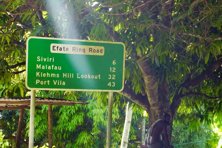
How Long Does it Take to Drive Around Port Vila and Efate?
Driving the full loop of Efate’s coastal ring road takes about 3 hours in a high-clearance vehicle without stops or 4-5 hours in a low-clearance vehicle or bus (minivan). The road is approximately 130 km (81 mi) long, winding past villages, lush forests and inland viewpoints.
Driving Times from Port Vila (Town Area) to:
(Kilometres / Miles / Minutes)
- Mele Village (Beach Area): 10 km / 6.2 mi / 30 mins
- Mele Cascades Waterfall: 11 km / 6.8 mi / 35 mins
- Havannah Harbour: 28 km / 17.4 mi / 50 mins
- Eton Village (East Coast): 35.5 km / 22 mi / 43 mins
- Eton Beach: 37 km / 23 mi / 45 mins
- Emua (Wharf for Nguna/Pele): 47 km / 29 mi / 1 hr 10 mins
Driving Times from Bauerfield International Airport to:
(Kilometres / Miles / Minutes)
- Port Vila (Town Area): 6 km / 3.7 mi / 15 mins
- Mele Village: 6.7 km / 4.2 mi / 20 mins
- Havannah Harbour: 24.7 km / 15.3 mi / 45 mins
- Eton Village: 39.5 km / 24.5 mi / 55 mins
- Emua (Wharf for Nguna/Pele): 43.9 km / 27 mi / 1 hour
Boat & Flight Times from Efate (Port Vila) to:
- Santo (Luganville): 300 km / 186 mi / 50 mins by plane / 10-24 hours by ferry
- Tanna Island: 230 km / 143 mi / 45 mins by plane / 15-16 hours by ferry
- Malekula Island: 190 km / 118 mi / 45 mins by plane / 7-14 hours by ferry
Learn more about inter-island transport in our guide, Domestic Flights in Vanuatu: Your Guide to Interisland Flights and Vanuatu Ferry Guide: How to Use the Ferry for Interisland Travel in Vanuatu.
Walking Times on Port Vila and Efate
You’ve probably heard that Port Vila and Efate are also great for easy walks and multi-day hikes. For waterfall walks, coastal strolls and lookout trails, take a look at The Best Walks & Hikes in Vanuatu.
Travel Times On/From Espiritu Santo (Santo)
Espiritu Santo is Vanuatu’s largest island and one of its most rewarding destinations, known for white sand beaches, blue holes, WW2 history and lush jungle landscapes. The island is typically accessed via domestic flights from Port Vila into Santo-Pekoa International Airport (Luganville), though multiple ferry services also operate between Port Vila and Luganville.
Once on land, getting around Santo is usually done via accommodation transfers, rental cars, tour companies, taxis or local trucks. Road infrastructure on the east coast is acceptable for rental vehicles; however, prepare for a much slower journey if you're taking the south coast road.
How Long Does it Take to Travel Around Santo?
Santo does not have a completely sealed coastal loop, but it takes approximately 1 hr 30 mins along the Santo East Coast Road from Luganville, and 2 hrs 30 mins to 3 hours to drive from Luganville to the southern coastal area, depending on road conditions. The main accessible road network covers roughly 120 km (75 mi) through villages, rainforest and coastal landscapes.
Driving Times on Espiritu Santo From Luganville to:
(Kilometres / Miles / Minutes)
- Million Dollar Point: 8 km / 5.0 mi / 15 mins
- SS President Coolidge: 7.6 km / 4.7 mi / 12 mins
- Matevulu Blue Hole: 21.2 km / 13.2 mi / 29 mins
- Riri Blue Hole: 19.8 km / 12.3 mi / 27 mins
- Champagne Beach: 52.6 km / 32.7 mi / 1 hr 12 mins
- Port Olry Village: 63.6 km / 39.5 mi / 1 hr 18 mins
- Tuffuntari Waterfall (South Coast): 27 km / 17 mi / 1 hr 15 mins
Driving Times on Espiritu Santo From Santo-Pekoa Airport to:
(Kilometres / Miles / Minutes)
- Luganville (Town Area): 6 km / 3.7 mi / 10 mins
- Million Dollar Point: 4.1 km / 2.5 mi / 6 mins
- SS President Coolidge: 3.3 km / 2.1 mi / 5 mins
- Matevulu Blue Hole: 24.4 km / 15.2 mi / 31 mins
- Champagne Beach: 55.7 km / 34.6 mi / 1 hr 15 mins
- Tuffuntari Waterfall (South Coast): 33 km / 21 mi / 1 hr 25 mins
Boat & Flight Times from Santo to:
- Port Vila: 300 km / 186 mi / 50 minutes by plane / 10-24 hours by ferry
- Malekula: 130 km / 81 mi / 55 minutes by plane / 1 hr 30 mins to 6 hours by ferry
Learn more about inter-island routes and schedules in our guide Domestic Flights in Vanuatu: Your Guide to Interisland Flights and Vanuatu Ferry Guide: How to Use the Ferry for Interisland Travel in Vanuatu.
Travel Times On/From Tanna
Tanna Island is one of Vanuatu’s most iconic destinations, best known for Mount Yasur, one of the world’s most accessible active volcanoes. The island is typically accessed via domestic flights from Port Vila into Whitegrass Airport, with occasional inter-island connections from other islands.
Once on land, getting around Tanna is usually arranged through your accommodation, with most visitors relying on resort transfers, local trucks, 4WD vehicles or guided tours. Road conditions can be rough, especially outside the main areas, so travel times can vary.
How Long Does it Take to Travel Around Tanna Island?
Tanna is relatively compact, and it takes approximately 1 hr 30 mins to 2 hours to drive from the north of the island to the southern coast, depending on road conditions. The main road network covers around 85 km (53 mi), passing villages, plantations, coastal viewpoints and volcanic landscapes.
Driving Times on Tanna From Lenakel to:
(Kilometres / Miles / Minutes)
- Mt Yasur Volcano: 41.8 km / 26 mi / 1 hr 15 mins
- Port Resolution: 50.5 km / 31.4 mi / 1 hr 30 mins
Driving Times on Tanna From Whitegrass Airport to:
(Kilometres / Miles / Minutes)
- Lenakel (Main Town): 10 km / 6.2 mi / 15 mins (drive)
- Mt Yasur: 33.7 km / 21 mi / 1 hr (drive)
- Port Resolution: 42.4 km / 26.3 mi / 1 hr 15 mins (drive)
Boat & Flight Times from Tanna to:
- Port Vila: 230 km / 143 mi / 45 minutes by plane / 15 to 16 hours by ferry
Learn more about inter-island routes and schedules in our guide Domestic Flights in Vanuatu: Your Guide to Interisland Flights and Vanuatu Ferry Guide: How to Use the Ferry for Interisland Travel in Vanuatu.
Travel Times On/From Malekula Island
Malekula is Vanuatu’s second-largest island, known for its cultural richness, jungle hikes and dugong swimming, with landscapes ranging from coastal lagoons to rugged interior hills. The island is typically accessed via domestic flights from Port Vila into Norsup or Lamap Airports, with some limited inter-island shipping options available.
Once on land, getting around Malekula usually involves trucks and banana boats used as public transport, as road infrastructure is limited and often unsealed outside main settlements.
How Long Does it Take to Travel Around Malekula?
Malekula is larger than many of Vanuatu’s islands, and it takes approximately 4-5 hours to travel from the northern to southern settlements along the main roads. The main road network covers roughly 150 km (93 mi), although travel times can vary depending on road conditions, transport type and whether your driver decides that “almost there” means 20 minutes or one more island-time hour.
Driving Times on Malekula From Lakatoro to:
(Kilometres / Miles / Minutes)
- Norsup Airport: 5 km / 3.1 mi / 10 mins
- Walarano: 16.6 km / 10 mi / 30 mins
- North Bay: 18 km / 11.2 mi / 40 mins
- Devil’s Point (Northern Coast): 35 km / 21.7 mi / 1 hr 10 mins
- Lambubu Wharf: 20 km / 13 mi / 20 mins
Driving Times on Malekula From Lamap Airport to:
(Kilometres / Miles / Minutes)
- Lamap Village: 4 km / 2.5 mi / 10 mins
- South Coast Villages: 20 km / 12.4 mi / 40 mins
- North Coast (Devil’s Point area): 50 km / 31 mi / 1 hr 30 mins
Boat Times on Malekula From Lakatoro Wharf to:
(Kilometres / Miles / Minutes)
- Uri: 1.5 km / 0.9 mi / 10-15 mins
- Uripiv Island: 3 km / 1.9 mi / 15-20 mins
- Lamap: 70 km / 44 mi / 3-4 hrs
Boat Times on Malekula From Lambubu Wharf to:
(Kilometres / Miles / Minutes)
- Southwest Bay: 40 km / 25 mi / 2 hours
Flight and Boat Times to Malekula:
- Malekula from Port Vila: 162 km / 100 mi / 45 mins by plane
- Malekula from Santo: 67 km / 41 mi / 1 hr 30 mins to 6 hours by ferry
Learn more about inter-island routes and schedules in our guide Domestic Flights in Vanuatu: Your Guide to Interisland Flights and Vanuatu Ferry Guide: How to Use the Ferry for Interisland Travel in Vanuatu.
More About Vanuatu Travel Times and How Long it Takes to Travel Around Vanuatu
That's it for our guide to Vanuatu travel times and distances. Now that you know how long it takes to travel around Vanuatu, see more travel times in the following articles:
- What are the Flight Times to Vanuatu?
- Which Airlines Fly Directly to Vanuatu?
- How Long Does it Take to Sail to Vanuatu?
Finally, plan the rest of your adventure using The Complete Travel Guide to Vanuatu and the 30 Tips for Travelling in Vanuatu.

-%20BNCC%20CREDIT%20VanuatuPocketGuide.com-1-900x600.webp?v=2026-03-08T00%3A36%3A15.267Z)
%20CREDIT%20VanuatuPocketGuide.com-900x601.webp?v=2026-03-20T20%3A18%3A45.159Z)