

A Self-Drive Day Tour of Efate Island
Have a day to spend on Espiritu Santo and want to see more than just Luganville? This self-guided one-day itinerary takes you along the island’s scenic East Coast Road, linking together blue holes, beaches, World War Two history, lunch stops and one of Vanuatu’s most photogenic coastal villages.
Start in Luganville, then follow the main road northeast toward Port Olry, choosing the stops that suit your pace along the way. You don’t need to do every blue hole, beach and detour listed here in one day, as this route is designed to give you a variety of places to choose from depending on your interests, budget, swimwear situation and how long you end up floating around in impossibly blue water.
The East Coast Road is generally straightforward, but some attraction access roads are unsealed, so take it slow and consider a high-clearance vehicle. Otherwise, sightseeing tours can cover many of Santo’s highlights if you’d rather let someone else handle the driving.
This article is based on real on-the-ground research, not on AI scraping old content from the internet. Learn how we use AI!
Table of Contents
How to Get Around Santo Using This Self-Guided Itinerary
This self-guided one-day itinerary follows the East Coast Road from Luganville to Port Olry, covering around 134 km (83 mi) return with approximately 2 hrs 45 mins of driving time without longer stops.
The easiest way to follow the route is with a rental car, giving you the freedom to choose your blue holes, beaches, lunch stops and swimming breaks as you go. The main East Coast Road is generally straightforward, especially compared to some other island roads, but a high-clearance vehicle is still recommended for dirt access roads and attraction turn-offs.
Sightseeing tours are another good option if you’d rather not drive or navigate. They usually cover a selection of Santo’s highlights, such as blue holes, Champagne Beach and Port Olry, without you needing to think about turn-offs, entry fees or whether that dirt road is really the right dirt road.
Tips on these transport methods can be found in the following guides:
- The Guide to Car Hire in Vanuatu
- The Best Car Rentals in Luganville
- The Best Sightseeing Tours in Santo
For more transport options, check out the Santo Transport Guide: 10 Ways to Get Around Santo.
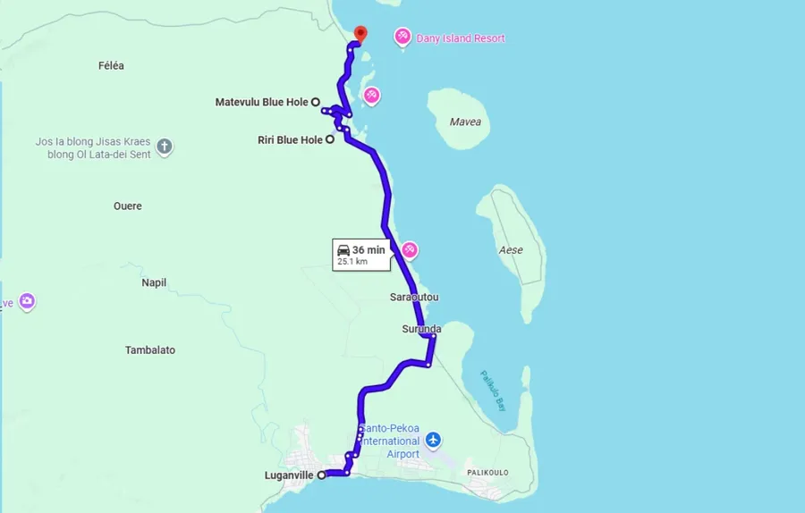
Luganville to Turtle Bay
Distance: 25 km (16 mi), Driving time: 35 minutes without stops.
Leaving Luganville
Start in Luganville, but don’t worry, we’re not going to list every stop in town here when you probably want to hit the road.
If you do want to explore close to town first, including nearby sights like Million Dollar Point, see the 30 Best Things to Do in Santo. For this itinerary, make the most of your day by heading straight onto the East Coast Road.
Follow the main road northeast out of Luganville, rather than taking Canal Road toward Palikoulo, where the road can deteriorate and slow the whole day down. As you drive, take note of a couple of free swimming holes around Surunda Bridge and Lopelope Bridge for the way back, if you still have energy later.
Melon River & Beach
Your first proper stop could be Melon River & Beach in Matevulu, signposted from the East Coast Road.
Follow the dirt road until you reach the chain, then ask permission and pay the entry fee at the house on the right when facing the chain. Once inside, you’ll find a peaceful riverside swimming spot with cool water, picnic benches, shade, bathroom facilities and changing areas.
The surprise extra here is the World War Two history. While waiting for access, look for the old plane wings and bomber remnants under shelter, and ask the owners about the additional wartime artefacts if you’re interested.
Riri Blue Hole
Nearby, Riri Blue Hole is one of Santo’s most beautiful blue hole experiences.
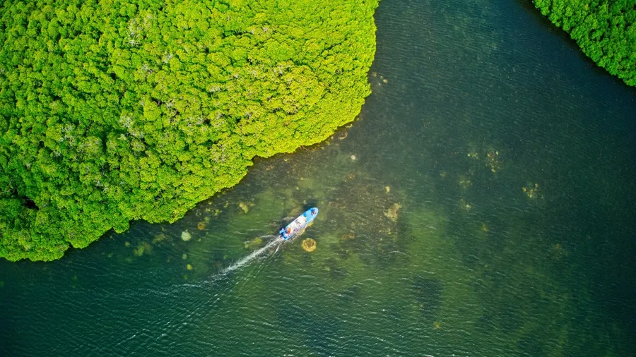
You can drive in by taking the turn-off just north of the bridge between Turtle Bay Lodge and Black Pearl Resort, then following the road for around 1 km (0.6 mi). However, the more memorable way to arrive is by outrigger canoe from the bridge, with guides usually waiting there.
The canoe ride takes around 20 minutes through peaceful, jungle-lined waterways, with the water shifting from emerald green to brilliant blue as you get closer. Once there, expect clear water, platforms, changing areas, toilets and a rope swing for those who can’t resist a dramatic entrance.
Learn more in The Best Blue Holes on Santo.
Turtle Bay Airfield
As you drive toward Matevulu Blue Hole, you’ll pass along the old Turtle Bay Airfield.
Built in July 1942, this wartime airfield became one of the major Allied air bases in the Pacific after Pearl Harbor. Nature has taken back much of the runway, but you can still trace parts of its outline as you drive the road toward Matevulu.
It’s one of those easy-to-miss Santo history moments, unless you know what you’re driving over. Now you do.
Matevulu Blue Hole
For another blue hole stop, take the signposted turn-off around 1.4 km (0.9 mi) south of the Matevulu River Bridge. Where there are two inland roads, take the one on your right and follow it for about 1.5 km (0.9 mi) to the end.
Matevulu Blue Hole is deeper and moodier than Riri, with clear water plunging to around 18 m (59 ft) and turning an opaque blue in the depths. The huge banyan tree at the water’s edge, rope swings, metal ladder and waterslide give it a more adventurous feel.
Bring cash for the entry fee, paid to the custodian or into the honesty box. Basic toilets, changing rooms and lounging areas are available.
Turtle Bay Lodge
If you’re hungry already, stop at Turtle Bay Lodge for lunch before continuing further along the East Coast Road.
It’s a convenient meal stop for this part of the island, especially if you’ve worked up an appetite swimming, paddling and pretending the rope swing was “just for photos”. See the 10 Best Restaurants in Santo for more places to eat around the island.
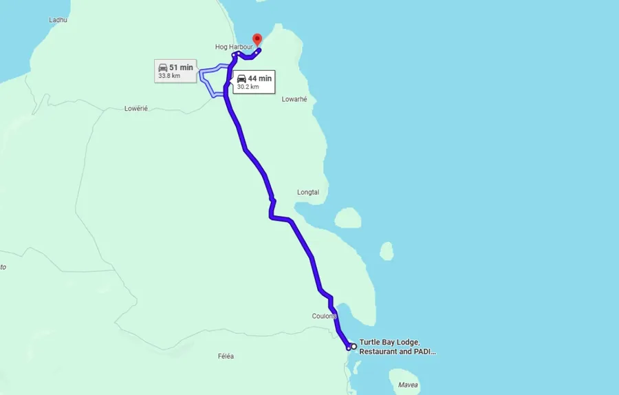
Turtle Bay to Champagne Beach
Distance: 30 km (19 mi), Driving time: 45 mins without stops.
Santo’s Blue Hole
Not too far north of Turtle Bay is one of Santo’s more underrated blue holes, known by a few names depending on which side you visit: Nanda Blue Hole, Jackie’s Blue Hole or Santo’s Blue Hole.
The water here is vividly blue, with decks, steps and jumping platforms for getting in, plus tropical fish swimming close to the edges. It’s a good spot for snorkelling around the limestone formations, or simply floating in the jungle shade and pretending you don’t have a schedule.
There are two deck areas with separate entry fees, with Santo’s Blue Hole on the west side and Jackie’s Blue Hole on the east side. The Santo’s Blue Hole side has changing rooms, restrooms and a bar area where fresh juices and food can be ordered on request.
For something more involved, Santo’s Blue Hole also offers a half-day agriculture and cooking experience with a garden tour, traditional cooking and blue hole access. Learn more in The Best Blue Holes in Santo.
Serah Botanical Garden
As you continue north and the road winds uphill, stop at Serah Botanical Garden if you have a booking.
Signposted along the main road around 10 km (6 mi) north of Turtle Bay Lodge, this one-hour tour introduces traditional Ni-Vanuatu plant knowledge, food crops and seasonal fruit. Demonstrations can include kava preparation and juice making, with fresh coconut juice and fruit included.
The garden also extends to a river where you can swim and enjoy a natural waterfall massage. Tours can be conducted in English or French.
Learn more about this tour in the 20 Best Foodie Experiences in Vanuatu.
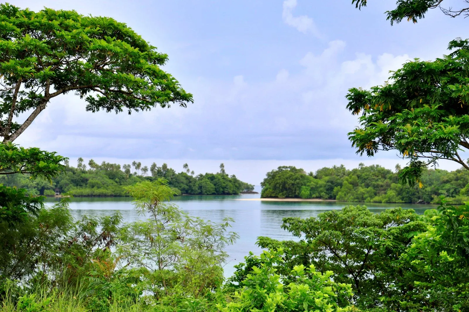
Champagne Beach
Further up the road, take the right turn off the main road toward Champagne Beach in Hog Harbour.
This is Santo’s poster-child beach for good reason, with a horseshoe-shaped bay, soft white sand and clear blue water. It was once busier with cruise ship visitors, but these days it’s usually easier to enjoy without big crowds.
Champagne Beach is open from 7 am to 6 pm daily, with changing rooms, showers, toilets and shaded areas. There are safe swimming areas across the bay, snorkel gear is available for hire and entry fees depend on your vehicle type.
Joylitas Restaurant serves meals such as fish and chips and pizza, while the bar usually opens for public holidays and special occasions. Camping is also possible, with details available at the entrance.
Learn more about it in the 10 Best Beaches in Vanuatu.
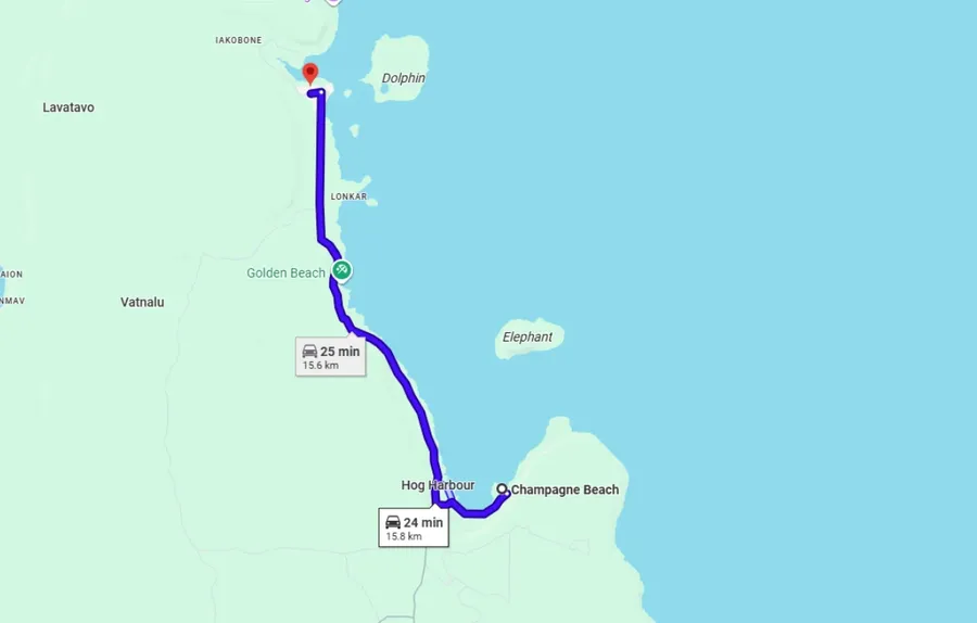
Champagne Beach to Luganville via Port Olry
Distance: 79 km (49 mi), Driving time: Allow around 1 hr 45 mins without stops.
Port Olry
From Champagne Beach, continue another 16 km (10 mi) - around 25 minutes - up the road to Port Olry.
The journey is part of the charm, following a scenic coconut tree-lined road before the beach suddenly opens up in front of you. Once there, you’ll find calm turquoise water, a relaxed village setting and local dugout canoes gliding across the lagoon.
Chez Louis’ Restaurant is the place to settle in. Order early, then swim, relax on the sand or chat with locals while you wait. If you’re lucky, you might even spot a turtle or dugong out in the water.
Horse riding is also available around Port Olry when booked in advance. See the 5 Best Horse Riding Tours in Vanuatu for more details.
Return to Luganville
From Port Olry, return to Luganville the same way you came along the East Coast Road.
This is your chance to stop at anything you skipped on the way up, whether that’s another blue hole, a beach, a lunch stop or one of the free swimming holes you noted near Surunda Bridge and Lopelope Bridge.
The nonstop return journey from Port Olry to Luganville is around 63 km (39 mi), taking approximately 1 hr 20 mins.
More About Planning a Self-Guided Day Trip on Santo
That’s it for our self-guided itinerary of Espiritu Santo. For more details about the sights visited on this one-day itinerary of Santo, these other articles should do just the trick!
- 30 Best Things to Do on Espiritu Santo
- The Food Guide to Espiritu Santo: Places to Eat & Food Tours
- 20 Free & Cheap Things to Do on Espiritu Santo
Finally, don’t miss a thing with The Complete Travel Guide to Espiritu Santo.

%20CREDIT%20VanuatuPocketGuide.com-900x506.webp?v=2026-06-10T02%3A50%3A37.509Z)